Sakatawi ... Grey Owl's
stomping ground
Sakatawi - What the heck is that
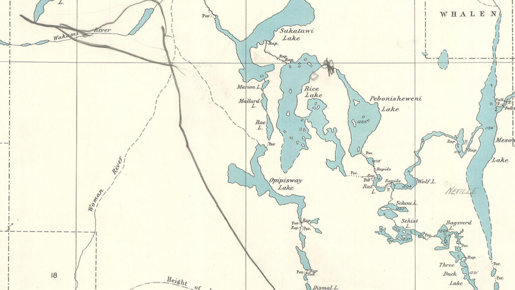
As you can see from this historic map - Dated 1914 - Sakatawi was the original name for what we now know as Rush Lake.
Notice the historic portages which depict access from the east via Wolf, Rat and Mouse Lakes or through Arbutus, Opipisway, Rae and Mallard.
Some of these portages were still in existence in the 1970's when we started exploring the area.
The portages along the Rush River and the Rice River were open and clear when we first encountered them in 1976.
The Bagsverd, Schist, Schou, Wolf, Rat and Mouse route was viable as we attempted to travel to Pebonisheweni in the 1980's.
Where is this place?

Grab your Ontario Road map and run your finger along Highway 400 North from Toronto to Sudbury and then continue north via Highway 144 to the intersection of Hwy 560.
Turn left at 560 (the Sultan Road) and head west. There are many logging roads branching off both north and south but at about the 24km mark you'll find New Arbutus Road. It'll take you north to a bridge over the outflow of Stony Lake and the access to Arbutus Lake.
Further west at about the 46km making a right turn (north) will lead you to the bridge spanning the Opeepeesway River just a little downstream from the lake of the same name.
At this point these are the primary access points for the historic Sakatawi route.
Why come here?
What is it that keeps drawing us back to this area?
Certainly it is not the ease of travel, the condition of the portages, the ease of access, the eight hour drive – including the last two across the Sultan Road and north on an old unmaintained logging road.
The deciding factor is always the remoteness of the area. In over thirty years of canoeing the area north of the Sultan Road we've never encountered another canoe party.
That's not to say that the area is deserted; you'll find fishermen on all the larger lakes. Those that have road access will have some locals and campers trying their luck with walleye fishing. The more remote lakes will likely contain fly-in fishing camps where we always get the same reaction …"How the %&*# did you guys get here?"
What's the route?

The original route was one that extended from the town of Biscotasing northward to Horwood Lake.
This is Grey Owl territory and this route was used for trading and for enforcement tours.
The route went north from Bisco to Flying Post Bay and then continued through a series of portages to Dismal Lake, Stony Lake and Arbutus Lake to arrive on Opeepeesway Lake.
From Opeepeesway Lake there were three possible routes to Horwood Lake ...
The first was to continue north to Little Rice Lake ... portage to Rice Lake ... north on Rice Lake to the Rice River ... descend the Rice River to Rush Lake ... Cross Rush Lake ... descend the Rush River to the Woman River and travel north to Horwood Lake
The second involved paddling to the northernmost bay on Opeepeesway Lake and portaging to Rae Lake then paddling through Mallard and Marion Lakes to Rush Lake ... from here follow the Rush and Woman Rivers as above.
The third was to cross Opeepeesway Lake and descend the Opeepeesway River to the junction of the Woman River and follow the Woman River to Horwood Lake.
Here's where my curiousity was aroused ... could we turn this into a circle route by starting and ending at Opeepeesway Lake?
The story begins in 1975 and continues ... so read on ....
© 2020 canoecouple.com All Rights Reserved.